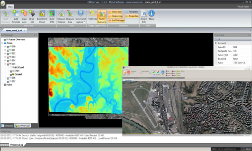
Automated digital terrain model and surface extraction
OPK Surf is an automated terrain and surface extraction environment providing highly precise digital terrain models (DTM) and digital surface models (DSM) derived from aerial imagery.
Intelligent multi-image matching through on-the-fly selection of the locally best suited images for DTM generation.
Extremely dense point clouds by using feature-based and least-squares matching techniques, with different strategies for DTM and DSM extraction. 3D Point extraction produces optimized 3D models by dynamic filtering of sensor noise.
OPK Surf is a part of OPK photogrammetry suite including several cartography software.
Point clouds, DSM and DTM are all GIS data compatible with most common geographic information systems (GIS).
Main features
- High Performance
- Dense DTM generation
- Dense DSM generation
- Area of Interest definition
- 3D Point cloud visualization
- Blocks of thousands of images
- Modular solution
- Accurate procedures
- User friendly interface
- Available for Windows Vista, 7 and 8 (32 / 64 bit)
Aerial Mapping
MakeUp

Software per GIS e Cartografia La suite OPK è un set di software per GIS e cartografia aerea dedicati al processamento di immagini large format acquisite con camere aeree o satelliti...
Maggiori InformazioniBlend

Software per GIS e Cartografia La suite OPK è un set di software per GIS e cartografia aerea dedicati al processamento di immagini large format acquisite con camere aeree o satelliti...
Maggiori InformazioniSurf

Software per GIS e Cartografia La suite OPK è un set di software per GIS e cartografia aerea dedicati al processamento di immagini large format acquisite con camere aeree o satelliti...
Maggiori InformazioniWarp

Software per GIS e Cartografia La suite OPK è un set di software per GIS e cartografia aerea dedicati al processamento di immagini large format acquisite con camere aeree o satelliti...
Maggiori InformazioniBundle

Software per GIS e Cartografia La suite OPK è un set di software per GIS e cartografia aerea dedicati al processamento di immagini large format acquisite con camere aeree o satelliti...
Maggiori InformazioniStartKit

Software per GIS e Cartografia La suite OPK è un set di software per GIS e cartografia aerea dedicati al processamento di immagini large format acquisite con camere aeree o satelliti...
Maggiori InformazioniSoftware Fotogrammetria
OPK SAT, Software per immagini da Satell…

A Multi-faceted approach Partner removes the hassle and confusion that comes from managing your tax burden effectively. Our tax services range from discrete, one-time advice to complete management and everywhere in...
Maggiori InformazioniOPK, Software per immagini da Aereo (2)

Software per GIS e Cartografia La suite OPK è un set di software per GIS e cartografia aerea dedicati al processamento di immagini large format acquisite con camere aeree o satelliti...
Maggiori InformazioniAPS - Photogrammetry Software

La suite OPK è un set di software per GIS e cartografia aerea dedicati al processamento di immagini large format acquisite con camere aeree o satelliti. OPK garantisce alte prestazioni...
Maggiori Informazioni
")